Links to maps of Dublin.
A guide to historic and modern maps of Dublin, from John Speed's 1610 plan and John Rocque's 1756 survey to street maps for visitors to the city.
Word count
486 words
A guide to historic and modern maps of Dublin, from John Speed’s 1610 plan and John Rocque’s 1756 survey to street maps for visitors to the city.
Historic maps of Dublin
The earliest detailed plan of the city is John Speed’s map of 1610, published in his atlas The Theatre of the Empire of Great Britaine. It shows a compact walled town on the south bank of the Liffey, with Dublin Castle, Christ Church and St Patrick’s, and Trinity College standing in open ground to the east.
The landmark of eighteenth-century Dublin mapping is John Rocque’s Exact Survey of the City and Suburbs of Dublin, published in 1756. Drawn at a large scale, it records individual buildings, gardens and yards, and is widely used by historians to picture the city just before the Wide Streets Commission, set up in 1757, began to reshape it. In the nineteenth century the Ordnance Survey mapped the whole of Ireland at six inches to the mile, followed by much larger-scale town plans of Dublin.
Maps on this site
This site does not host full-size map scans, but it does include Leonard Strangways’ 1904 map of the walls of Dublin. Many of the books here are arranged geographically and are best read with a map to hand: F. Elrington Ball’s parish histories, Dillon Cosgrave’s North Dublin, Mecredy’s tours of Dublin from 1905 and C. T. M’Cready’s Dublin Street Names, Dated and Explained. The guide to finding history by Dublin area lists the parish chapters by district.
The links below were collected when this page was first written. Several point to sites that no longer exist and now lead to archived copies where one could be found.
Maps
They take up a lot of space and they’re impossible to scan at full size - that’s my excuse for not providing any myself. However, if someone doesn’t put up Rocque’s map pretty soon, I may be forced to. Seriously, I hadn’t put any emphasis on maps but a lot of people are looking for them.
The first map is purely historical, all the rest are handy if you’re visiting the city or suburbs. If you’re still confused about where a place is, feel free to Email me:
Speed’s Map of Dublin (1610). Historic map of the old city. http://www.lib.utexas.edu/maps/historical/dublin_1610_1896.jpg
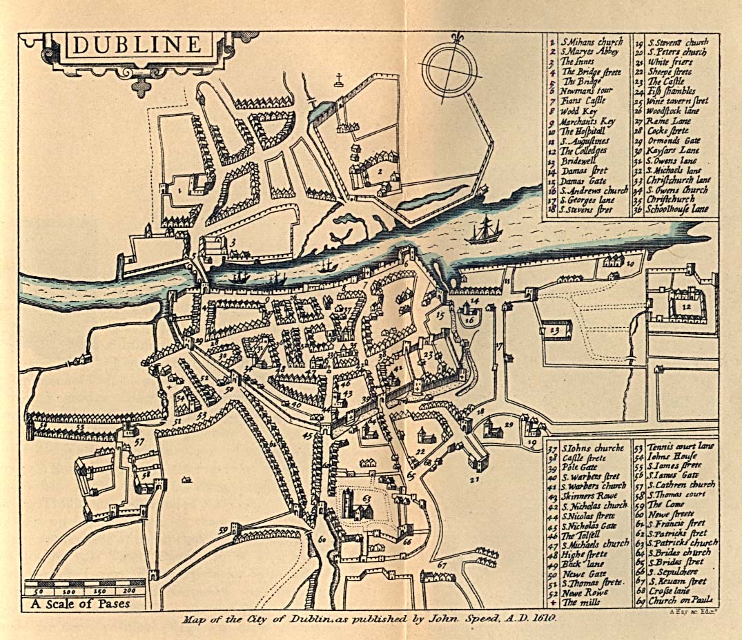
Large map of the city. The one to use. http://www.foundmark.com/Ireland/lists/DownMap/JPEGMap-Dub.html
Map of County Dublin. http://www.foundmark.com/Ireland/Dublin/Dubdetailmap.html
Interactive map of central Dublin. Slow to load but worth the wait. http://dublin.local.ie/general/interactive/#
Series of maps of central Dublin. About 70k each.
http://www.softguides.com/dublin/maps/centre.html
Route maps for Dublin Bus. If you’re thinking about taking public transport to or from the city: http://www.dublinbus.ie/ttable/mainmap.asp
Home.